By Catherine Owen Koning, Originally Published in The Monadnock Shopper News, Green Monadnock column, December 2025.
In mid-December, we went ice-skating (and ice-kiting, for the adrenaline junkies among us) on Pool Pond in Rindge. The ice was over eight inches thick, and it was plenty cold – about 5 degrees F when we woke up that Sunday morning. There was even enough snow for cross country skiing in Keene. There’s over 170” of snow on Jay Peak in Vermont. Temperatures in the Northeastern US were 10 to 15 degrees F below the historic average. It looked like we are going to have a good old-fashioned winter again… so much for climate change, eh?!
Not so fast, friends! After that cold stretch, we lost all our snow to warm weather and heavy rainfall, 52 degrees F and rainy by December 19th. What gives with these wild swings in weather? The answer is: The Polar Vortex, which is a weakening of the jet stream. The jet stream is a narrow band of fast-moving air five to nine miles above us, flowing around the globe, roughly west to east, and moving with the seasons. If you’ve ever encountered turbulence on an airplane, chances are you have met the jet stream! So let’s dive into it.
We all know that heat flows from hot to cold. On a global scale, this explains the movement of air from the warm areas of the equator, to the cold areas of the north and south poles. As the earth turns, this deflects the air movement so it flows from west to east in the northern hemisphere. The greater the difference in temperature is, the faster the jet stream moves, just like water flows faster down a steeper slope. When the winter jet stream is moving fast, it keeps the cold air locked in a low pressure system around the poles. The jet stream acts like a barrier to weather systems, pushing them one way or another.
As the planet warms because of climate pollution, ice and snow in the polar areas has been melting. Ice and snow are light colored, reflecting light and creating a cooling effect. When the ice and snow melt, dark areas of ocean or land are revealed; since dark colors absorb light, this accelerates the warming of polar areas. The Arctic is warming nearly four times faster than the rest of the planet. As a result, the difference in temperature from equator to poles is reduced, so the fast-moving jet stream becomes more like a slow, lazy river, creating big S-shaped meanders. These meanders create big lobes or loops, allowing cold air to dip further south, reaching as far as Florida (cold snaps that endanger the orange crop!) and Texas. See diagram below, used with permission from Inside Climate News.
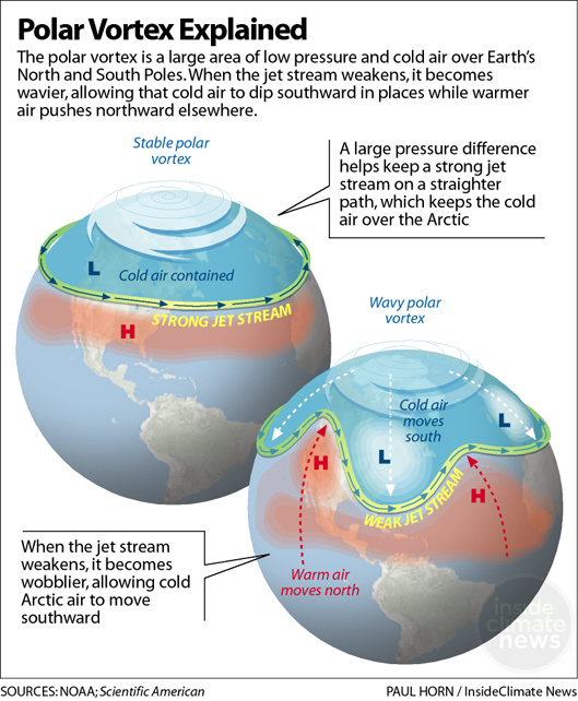
As the wavy jet stream moves, the lobe of cold air is displaced by a lobe bending the other way, with warm air moving in, and just like that, our frigid weather becomes rainy and spring-like. What would have been excellent snow for skiing and sledding came down as buckets of rain on December 19th. With these rapid changes in weather week by week, we will need to keep raincoats, ice scrapers, umbrellas, snow boots, and all manner of weather-proofing handy.
We can take action to reduce these climate change induced impacts. Check out the Monadnock SustainabilityHub.org website to find out what you can do in your own life to address climate change. In a future column, we will explore what towns can do to help their residents prepare for weather extremes.
Catherine Owen Koning is a Professor of Environmental Science at Franklin Pierce University, where she co-coordinates the Institute for Climate Action. She is also a member of the Monadnock Sustainability Hub’s Board of Directors and co-chairs the Keene Clean Energy Team.